
![]() This week was another busy week on the road.
This week was another busy week on the road.
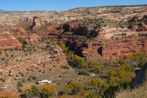
Our first destination was Capitol Reef National Park which we crossed in one day. We went on two short hikes; the first took us to a narrow canyon. The rocks on each side were very high. It was incredibly beautiful but also made me feel quite claustrophobic! The second led to a natural bridge: Hickmann bridge. There was a part of the trail that had signs saying to walk fast due to recent rock fall; Not very reassuring!
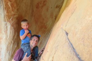
On our way out of the Park we stopped to admire some petroglyphs on the rocks showing people and animals made over 1000 years ago by Fremont Indiens. It’s amazing how long they have survived. That night we slept in a motel in a small farming village 30 minutes from the park.
The next day we drove 4 hours to Bryce canyon NP along highway 12 which is another one of America’s 99 scenic routes. It is one of only 27 in the country to have been given the title “all american road”for it’s outstanding beauty. It is 198 km long and goes through diverse landscapes, over forested Boulder mountain with an altitude of 2900 m, through Dixie national forest and then through the Grand staircase Escalante National monument, which is a huge waterless region so inhospitable that it was the last to be mapped in the continental USA.
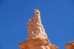
We got to Bryce in the early afternoon and took a short walk along the top of the canyon (known as the amphitheatre), which is filled with huge stone spires called hoodoos, eroded over millions of years from the cliff walls.


Bryce is at an altitude of around 2500 m and so the nights get very cold. After our experience in Yellowstone we preferred to book a motel for two nights in the town of Panguitch, a 30 minute drive from the park.
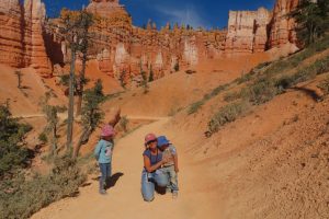
The next day we went back to Bryce to do a 5km hike into the canyon. Christophe carried Tom down as the path was narrow with a steep drop. Once at the bottom we saw a hoodoo that is called “the Queen” for it’s ressemblance to Queen Victoria and Louise discovered another one that looked like Fuzzbert a character from the Trolls movie!
During the afternoon we drove all the way through the park, saw several other viewpoints and did another short hike in a small forest with an altitude of more than 2700 metres. Once again we had to be careful with Tom as some parts of the path ran right along the edge of the canyon. That day Louise walked more than 8km!\
The following morning we drove three hours to the town of Page, located just over the Arizona state line, where we had booked a small house through airbnb. On the way there we stopped to visit Horseshoe Bend. It is a very high U shaped canyon, at the bottom of which runs the Colorado river. It is breath taking, but not for the faint hearted! We are always surprised to see that in a very safety conscious country there are all these places with huge drops, possible rock fall and no barriers! It is much more beautiful that way, but it makes it extremely nerve racking with young children! Luckily Tom was much more interested in a big digger on the way to the canyon than the view itself!


The next day we visited Antelope Canyon, which is situated within a huge Navajo Indian reserve. We had to book our tour in advance and be there at 10:30 am. Pretty straight forward, except that there is a 1 hour time difference between Utah and Arizona and upon arriving in Page we had moved our watches forward. However the Navajos follow Utah time (pacific time) and not Arizona time (mountain time zone ) Also Arizona does not apply day light saving time as opposed to the rest of the USA and the Indian nations. It is extremely confusing and we had to call up to check that we were on the right time! Luckily to simplify things the Navajos decided not to apply summer time in Antelope canyon, so in Summer it is the same time in the canyon as in Page!!
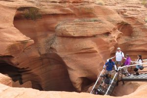
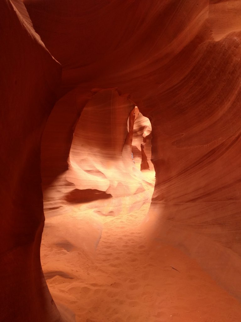
Antelope canyon is known as a “slot canyon” as it is extremely narrow. It is divided into lower and upper antelope canyon. The canyon is managed by the navajos and only accessible on a guided visit. It is a huge source of income for the navajo nation. We visited lower antelope canyon into which you have to descend going down a series of very steep steps. Louise was able to go down them by herself, but Christophe had to carry Tom. The visit lasted 90 minutes and was very beautiful. Unfortunately due to it’s success it is also extremely crowded, with bus loads of tourists coming to see it.
We spent the rest of the afternoon at Lone rock beach, on the edge of lake Powell. Lake Powell is an artificial lake created by the flooding of Glen Canyon with the creation of the Glen Canyon dam. It took 17 years for the lake to fill after completion of the dam in 1964. The lake is part of a larger network of dams which supplies water to 5 states (Wyoming, Utah, Arizona,Colorado and New Mexico) It has also become a popular recreation area with beaches, marinas and campgrounds.


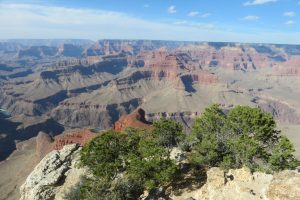
On Friday we left Page for Sedona (Arizona). On the way we made a stop at the Grand Canyon (South rim) It was a very quick visit as it was a two hour and a half hour drive there and then another two hours to our campground just south of Sedona, where we needed to arrive before nightfall. We only had about half a day to visit the park.
We headed for the visitor centre and to Mather point just behind it and then caught the park buses to various other view points along the top of the canyon. It was very busy, but we still got to see some amazing views. The Grand Canyon is part of a geological area know as the Grand Staircase. With the Grand canyon at the bottom, Zion national park in the middle and Bryce canyon at the top it is the world’s most complex sequence of uninterrupted sedimentary rock which recounts a history of 525 millions years. Every step marks a different chapter of the planet’s history and the time in which humans have been on the planet just a few lines at the end of a very long book. It makes you feel very very insignificant…


We are now headed for Sedona…
Stay tuned…


![]() Encore une semaine très chargée sur la route… Notre première destination était le parc national de Capitol Reef, que nous avons traversé Dimanche. La route était très belle, avec de nombreux points de vue. Nous avons fait également 2 petites randonnées. La première nous a emmenés dans un canyon très étroit. Une vue magnifique au milieu des roches très hautes de part et d’autre. Il ne faillait pas être claustrophobe !!!
Encore une semaine très chargée sur la route… Notre première destination était le parc national de Capitol Reef, que nous avons traversé Dimanche. La route était très belle, avec de nombreux points de vue. Nous avons fait également 2 petites randonnées. La première nous a emmenés dans un canyon très étroit. Une vue magnifique au milieu des roches très hautes de part et d’autre. Il ne faillait pas être claustrophobe !!!
Dans la second randonnée, nous sommes passés sous un pont naturel : Hickman Bridge. Les risques d’éboulement sont étaient clairement indiquées à l’entrée… Inutile de dire qu’on est pas restés très longtemps en dessous…
Avant de sortir du parc, nous avons observés des pétroglyphes sur une falaise, représentant des formes humaines et des animaux, gravés par des indiens Fremont il y a plus de 1000 ans.
Après une bonne nuit de sommeil dans un motel, nous avons pris la direction du parc national de Bryce Canyon, pour 4 heures sur une route scénique (la route US 12), portant le label “One of America’s 99 scenic routes”. Début de la visite du parc par quelques vues et une petite marche sur un chemin qui surplombe le Canyon. Nous avons attendu le couché du soleil car la vue est très jolie à ce moment de la journée. Malheureusement pour nous, ce jour là la lumière n’était pas idéale. Un bon moment tout de même à observer les “hoodoos” (sortes d’aiguilles de roche). La formation de ces piques s’est fait pendant des millions d’années avec l’érosion des falaises.
Ici, les nuits sont très froides (jusqu’à -4°C), nous avons donc préféré dormir, une fois de plus, dans un motel (dans la ville de Panguitch), pour 2 nuits. Ce qui nous a laissé la journée entière du lendemain pour finir la visite du parc.


Après notre petit-déjeuner et la leçon de Louise, nous sommes retournés dans le parc pour une randonnée de 5 kms dans laquelle nous sommes descendu dans le canyon. Une fois en bas, nous avons pu observer un hoodoo appelé “the Queen” pour sa ressemblance à la reine Victoria. Un peu plus tard, Louise en a même découvert un en forme de Fuzzbert, un personnage du dessin animé “The Trolls”… 🙂
Ensuite nous avons vus plusieurs points de vus et un autre pont en roche : Natural Bridge. Nous avons terminés la journée par une autre randonnée dans une petite forêt à plus de 2700 mètres d’altitude. Il a encore fallu faire très attention à Tom car à certains endroits le chemin longeait le bord de la falaise. Ce jour là, Louise à marché plus de 8 kms.
Le jour suivant, nous avions 3 heures de route pour rejoindre la ville de Page, dans l’Arizona, où nous avons passés 2 nuits dans une petite maison. Le premier point que nous avons visité était le Horseshoe Canyon. Il s’agit d’un canyon en forme de fer à cheval, avec en bas, l’eau vert émeraude du Colorado. Toutefois, il ne faut pas avoir le vertige pour prendre une photo à cet endroit.
Tom a cependant été plus intéressé par un bulldozer sur le chemin !!!
Le lendemain, nous avons visité Antelope Canyon, qui se situe dans un territoire indien, dans la réserve Navajo, en Arizona. Il y a 1 heure de décalage horaire entre l’Utah et l’Arizona, sauf dans la réserve indienne, qui est à la même heure que l’Utah. Aussi, en Arizona, il n’y a pas de changement d’heure d’été contrairement au reste des USA, y compris les réserves indiennes. Tout ceci est bien compliqué et prise de tête…
Mais heureusement, pour simplifier, les Navajos ont décidés de ne pas appliquer l’heure d’été à Antelope Canyon, et donc ce dernier est à la même heure que la ville de Page, pendant l’été. Ouf… On est sauvés !!!
Antelope Canyon est un “slot canyon”, c’est à dire un canyon extrêmement étroit. La visite du canyon ne peut se faire qu’avec une visite guidée. C’est une énorme entrée d’argent pour la réserve Navajo, qui se gère de manière quasi autonome. La visite commence en descendant une séries d’échelles très raides, puis une balade à pied au fond du canyon.


Le reste de l’après-midi nous sommes allés au lac Powell, un lac artificiel en amont du barrage de Glen Canyon. Il a fallut 17 ans pour remplir ce lac après avoir mis en place le barrage en 1964. Le lac est devenu un endroit très touristique avec des plages et des centres de sports nautiques. Ce barrage fournit plusieurs états en eau et en électricité, cependant sa construction a été très controversée car il a englouti de nombreux vestiges indiens et un beau canyon.
Vendredi, départ de Page pour Sedona, où il fait nettement plus chaud pour nos nuits de camping et où nous resterons 5 jours. Ce sera l’occasion de revoir pour la dernière fois Jessica et Dirk, nos amis Allemands. En chemin, nous sommes passés par le Grand Canyon que nous avons visité en une demi-journée.
Le Grand Canyon fait parti d’une région que les géologues appellent “the Grand Staircase” (le grand escalier). Le Grand Canyon étant point le plus bas, Zion NP au milieu et Bryce Canyon au sommet. C’est le seul endroit au monde où l’on peut voir un enchaînement ininterrompu de roche sédimentaire qui couvre 525 millions d’années de l’histoire de la planète. Si chaque marche est un chapitre différent, le temps que l’homme a passé sur terre ne représente que quelques lignes sur la dernière page de ce très grand livre. On se sent très insignifiant…


Nous nous dirigeons maintenant vers Sedona (Arizona)…
Stay tuned…

The antelope canyion est tellement beau!
Bravo bravo ma Louise , plus de 8 km c’est fantastique. J’aurais tellement aime faire cela avec toi.